
Garmin Seekarten für Kartenplotter
Elektronische Seekarten für Garmin Kartenplotter
Mit einer passenden Garmin Seekarte wird Ihr Kartenplotter zur detaillierten Navigationszentrale an Bord. Bei LEPPER marine finden Sie elektronische Garmin Karten und Seekarten für zahlreiche Fahrtgebiete – von der europäischen Küste bis zu internationalen Revieren.
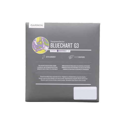
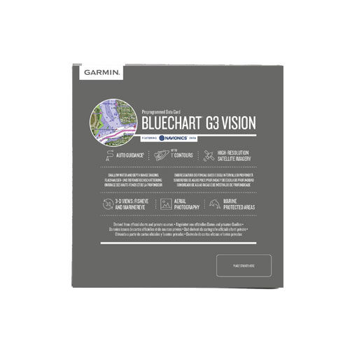
Unser Sortiment umfasst die vier Garmin Kartenwelten BlueChart g3, BlueChart g3 Vision, Garmin Navionics+ und Garmin Navionics Vision+.
Wählen Sie zunächst die gewünschte Kartenserie und anschließend das Fahrtgebiet und die passende Kartenversion für Ihren Garmin Kartenplotter.
Wichtig: Achten Sie vor dem Kauf unbedingt auf die Kompatibilität Ihres Garmin Kartenplotters und die jeweils unterstützte Kartengeneration.
Garmin Kartenplotter prüfen
Nutzen Sie zur sicheren Auswahl die offizielle Garmin-Kompatibilitätsübersicht. Dort können Sie prüfen, welche Garmin Seekarten und Funktionen mit Ihrem Kartenplotter kompatibel sind.

microSD™/SD™ card: HXAF003R - Western Africa
General coverage of the west coast of Africa from El Aaraich, Mor. to Cape Cross, Nam., including Abidjan, C.I., Douala, Cam. and Luanda, Ang. Included in this overall general coverage are a number of detailed charts covering areas such as Casablanca, Mor., Dakar, Sen., and Lagos, Nig. Also includes general coverage of St. Helena Is., Ascension Is., and the Azores. Also includes detailed coverage of the Madeira Islands, Canary Islands, and Cape Verde Islands.

microSD™/SD™ card: HXUS030R-Southeast Caribbean
Covers the Caribbean from Haiti to Trinidad & Tobago including Puerto Rico and all of the Lesser Antilles. Also includes the Colombian and Venezuelan coasts from Barranquilla, Colombia to the mouth of the Orinoco River including Lake Maracaibo and the Gulf of Paria.
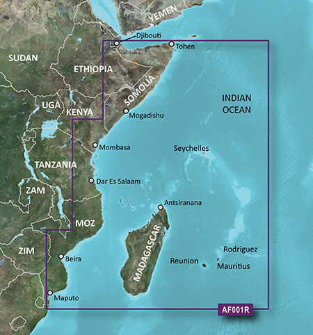
microSD™/SD™ card: VAF001R-Eastern Africa
Details: Informationen Produktcode VAF001R Name Eastern Africa Typ Garmin BlueChart g3 Vision Abdeckung General coverage of the east coast of Africa from the Gulf of Tadjoura to the Bay of Maputo, including Mogadishu, Som., Mombasa, Ken., and Dar es Salaam, Tan. Also includes general coverage of the entire coast of Madagascar. Includes detailed coverage of Djibouti, Dji., Maputo, Moz., Mauritius, Reunion, and the Seychelles. Kompatibilität siehe Reiter Kompatible Plotter Kartenupdate Hier klicken
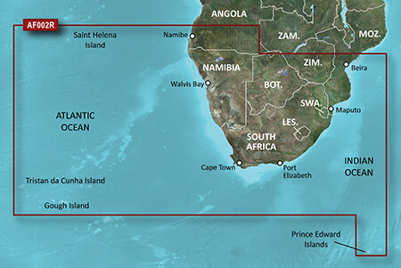
microSD™/SD™ card: VAF002R-South Africa
Details: Informationen Produktcode VAF002R Name South Africa Typ Garmin BlueChart g3 Vision Abdeckung Detailed coverage of the coast of southern Africa from Namibe, Ang. to Angoche, Moz., including the South African cities of Cape Town and Port Elizabeth. Includes detailed coverage of Durban S. Af. and Maputo, Moz. Also includes detailed coverage of the Tristan da Cunha Group, the island of St. Helena, and the Prince Edward Islands. Kompatibilität siehe Reiter Kompatible Plotter Kartenupdate Hier klicken
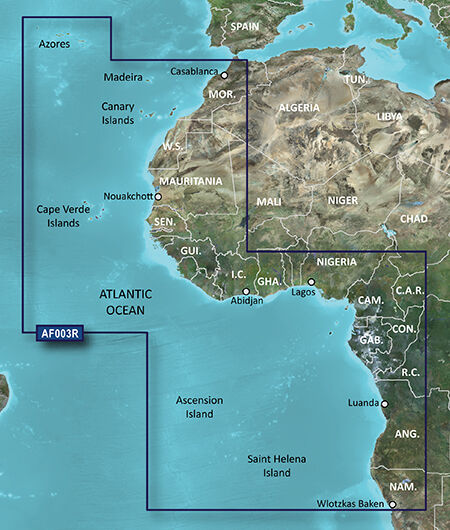
microSD™/SD™ card: VAF003R-Western Africa
Details: Informationen Produktcode VAF003R Name Western Africa Typ Garmin BlueChart g3 Vision Abdeckung General coverage of the west coast of Africa from El Aaraich, Mor. to Cape Cross, Nam., including Abidjan, C.I., Douala, Cam. and Luanda, Ang. Included in this overall general coverage are a number of detailed charts covering areas such as Casablanca, Mor., Dakar, Sen., and Lagos, Nig. Also includes general coverage of St. Helena Is., Ascension Is., and the Azores. Also includes detailed coverage of the Madeira Islands, Canary Islands, and Cape Verde Islands. Kompatibilität siehe Reiter Kompatible Plotter Kartenupdate Hier klicken

microSD™/SD™ card: VAF450S-Madeira and Canary Islands
Details: Karte BlueChart® g3 Vision Seekarte VAF450S auf microSD/SD-Karte Garmin Typ BlueChart g3 Vision Kartographie See Kartographie Land nur in Küstennähe Kartographie Straße nein Verfügbare Speichermedien Je nach Plottermodell auf folgenden Speichermdien lieferbar. Siehe unten (010-C0750-00) auf microSD/SD-Karte Bezeichnung VAF450S Name Madeira & Canary Islands Abdeckung Detailed coverage of the Arquipélago da Madeira and the Canary Islands with detailed port plans including Arrecife, Puerto del Rosario, and Caniçal. Includes general coverage of the southwestern coast of Morocco from Marruecos, Mor. to El Aauin in Western Sahara. Hersteller Link www.garmin.de Karten Update
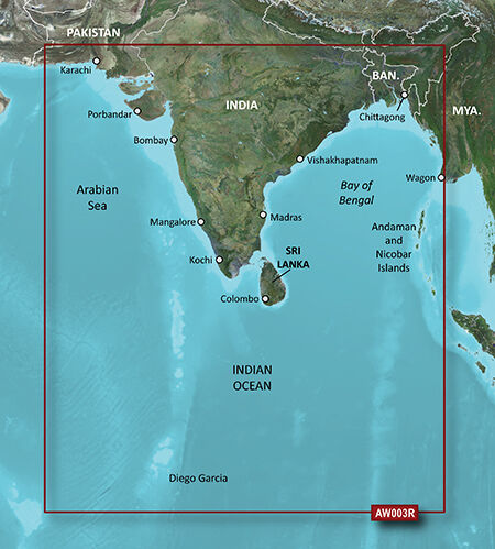
microSD™/SD™ card: VAW003R-Indian Subcontinent
Details: Informationen Produktcode VAW003R Name Indian Subcontinent Typ Garmin BlueChart g3 Vision Abdeckung General coverage of the Indian subcontinent from Pasni, Pak., to Sandoway, Myan. Included in this overall general coverage are a number of detailed charts covering areas such as the Indian cities of Mangalore, Quilon, and Calcutta. Also includes general coverage of Sri Lanka, the Andaman and Nicobar Islands, the Chagos Archipelago, and the Maldives, except for the detailed coverage of the Male Atoll Kompatibilität siehe Reiter Kompatible Plotter Kartenupdate Hier klicken
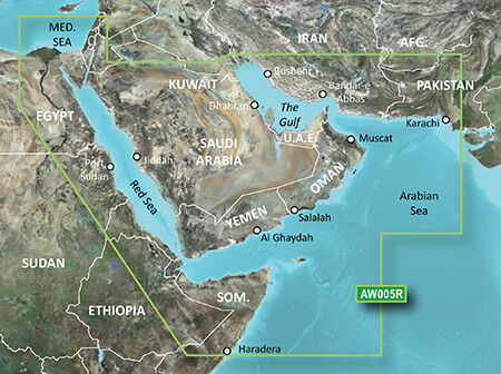
microSD™/SD™ card: VAW005R-The Gulf and Red Sea
Details: Informationen Produktcode VAW005R Name The Gulf & Red Sea Typ Garmin BlueChart g3 Vision Abdeckung Coverage of the Arabian Penninsula beginning at the Mediterranean Sea from Beirut to Alexandria. Coverage includes the Suez Canal, Gulf of Aqaba, and the Red Sea and Gulf of Aden in their entirety. Includes the Strait of Hormuz, Gulf of Oman, and coast of Somalia in the south. Coverage the of Kuwait, Saudi Arabia, Qatar, United Arab Emirates, along the southern coast of the Gulf and Iran along the northern coast. Coverage of Yemen and Oman coasts along the Indian Ocean to the Gulf of Oman, including Pakistan along the north coast, with general coverage of the Arabian Sea from Qamar Bay to the Delta of the Indus River. Included in this overall general coverage are numerous detailed charts covering areas such as Alexandria, Egy., Beirut, Leb., Al-Fuhaihil, Ad- Dammam, Bahrain, Ad-Dauha, and Abu Dhabi.Jiddah, Sau., Djibouti, Dji., and Aden, Yem. Kompatibilität siehe Reiter Kompatible Plotter Kartenupdate Hier klicken

microSD™/SD™ card: VUS030R-Southeast Caribbean
Details: Informationen Produktcode VUS030R Name Southeast Caribbean Typ Garmin BlueChart g3 Vision Abdeckung Covers the Caribbean from Haiti to Trinidad & Tobago, including Puerto Rico and all of the Lesser Antilles. Also includes the Colombian and Venezuelan coasts from Barranquilla, Colombia to the mouth of the Orinoco River, including Lake Maracaibo and the Gulf of Paria. Kompatibilität siehe Reiter Kompatible Plotter Kartenupdate Hier klicken

microSD™/SD™ card: VUS031R-Southwest Caribbean
Details: Informationen Produktcode VUS031R Name Southwest Caribbean Typ Garmin BlueChart g3 Vision Abdeckung Detailed coverage of the northern coast of Central America from Cancun, Mexico to Barranquilla, Colombia, including the Panama Canal in its entirety. General coverage of the northern half of the Gulf of Panama. Also includes detailed coverage of the coasts of Cuba, Jamaica, and the Caymans in their entirety Kompatibilität siehe Reiter Kompatible Plotter Kartenupdate Hier klicken

microSD™/SD™ card: VUS032R-Southern Gulf of Mexico
Details: Informationen Produktcode VUS032R Name Southern Gulf of Mexico Typ Garmin BlueChart g3 Vision Abdeckung Covers the Gulf of Mexico from Matagorda Bay to Belize City, including Corpus Christi, TX, Veracruz, Mex., the Bay of Campeche, Cancun, Mex., and Cozumel, Mex. Kompatibilität siehe Reiter Kompatible Plotter Kartenupdate Hier klicken

MicroSD™/SD™ Karte: TOPO Deutschland v9 PRO
Wir können dich bei der Navigation in Deutschland unterstützen – von der Nordseeküste bis hoch in die Alpen. Diese topografische Karte im Referenzmaßstab 1:25.000 bietet aktualisierte und genaue Daten.Erweitertes Netz von Trails für Freizeitaktivitäten, detailliertes Netz von Wanderwegen für touristische Gebiete und Netz von Trails für Langstreckenwanderungen für das gesamte Land.Zeigt Tourismus- und Routeninformationen an, darunter mehr als 340.000 km an Radfahrrouten, Mountainbike-Wegen und beliebten Wanderwegen.ActiveRouting1 zum Anpassen und Planen von speziellen, auf deinem Benutzerprofil basierenden Routen für das gesamte Streckennetz von Straßen und Trails. Auf der aktivitätsspezifischen Karte werden Highlights der vorgeschlagenen Radfahr- und Wanderrouten angezeigt.Adresssuche mit Hausnummern.Digitales Höhenmodell (DHM) mit Höhenkonturen in 20 Meter Intervallen.Spezielle Winterkarte mit Inhalten für Winteraktivitäten, beispielsweise Skipisten, Skilifte und Gebiete mit steilen Hängen.1 Vollständige ActiveRouting-Funktionen werden nur von bestimmten Produkten unterstützt; abhängig von Garmin Produkt und Softwareversion.
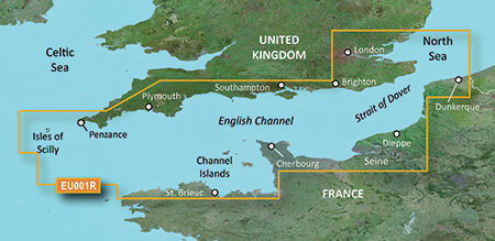
VEU001R-English Channel
Details: Informationen Produktcode VEU001R Name English Channel Typ Garmin BlueChart g3 Vision Abdeckung British coast: covers from Felixstowe to the Isles of Scilly, including Dover, The Solent, and the Isle of Wight. Also covers the River Thames from Twickenham to the North Sea. French coast: covers from Dunkerque to L'Aber Wrac'h, including Rouen and the Channel Islands Kompatibilität siehe Reiter Kompatible Plotter Kartenupdate Hier klicken
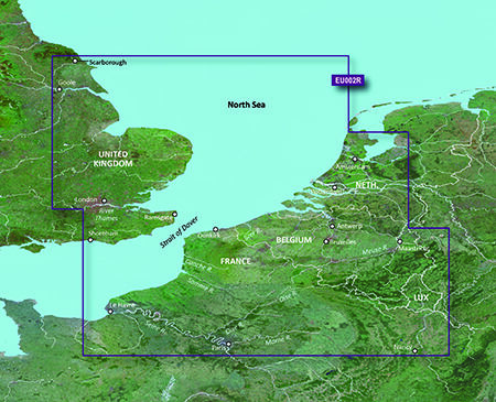
VEU002R-S/E England-Belux Inland Waters
Details: Informationen Produktcode VEU002R Name Dover-Amsterdam & England S/E Typ Garmin BlueChart g3 Vision Abdeckung British coast: from Scarborough Harbour to Newhaven, including River Thames to London. Continental coast: from Amsterdam to Fecamp. Kompatibilität siehe Reiter Kompatible Plotter Kartenupdate Hier klicken
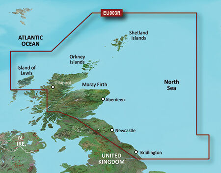
VEU003R-Great Britain, Northeast Coast
Details: Informationen Produktcode VEU0036R Name Great Britain, Northeast Coast Typ Garmin BlueChart g3 Vision Abdeckung Covers from the Isle of Lewis, Scotland to Bridlington Harbour, England, including Gairloch, the Shetland Islands, Edinburgh, and North Sea offshore charts. Also includes the Caledonian Canal, Loch Linnhe, and Loch Ness. Kompatibilität siehe Reiter Kompatible Plotter Kartenupdate Hier klicken
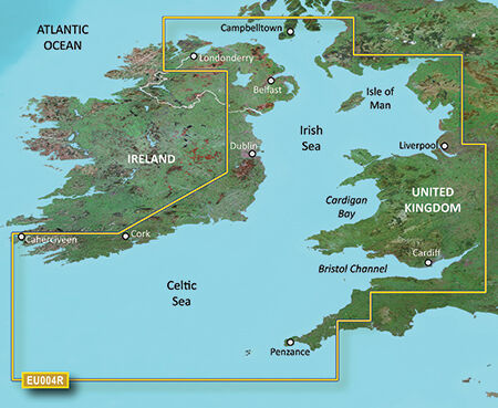
VEU004R-Irish Sea
Details: Informationen Produktcode VEU004R Name Irish Sea Typ Garmin BlueChart g3 Vision Abdeckung British coast: covers from Port Ellen on the Isle of Islay to Falmouth, including the Isle of Man and the Isles of Scilly. Irish coast: covers from Sheep Haven to Caherciveen, Republic of Ireland, including Londonderry, The Storks, Belfast, and Dublin. Kompatibilität siehe Reiter Kompatible Plotter Kartenupdate Hier klicken
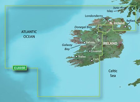
VEU005R-Ireland, West Coast
Details: Informationen Produktcode VEU005R Name Ireland, West Coast Typ Garmin BlueChart g3 Vision Abdeckung Detailed coverage of the north and western coasts of Ireland from Cork to Belfast including the Shannon Inland and Shannon-Erne Waterways, Galway Bay and Lough Neagh. Also included is the southwestern Scottish coast from Colonsay to Campbeltown. Kompatibilität siehe Reiter Kompatible Plotter Kartenupdate Hier klicken
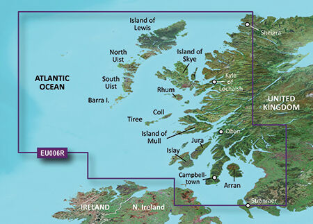
VEU006R-Scotland, West Coast
Details: Informationen Produktcode VEU046R Name Scotland, West Coast Typ Garmin BlueChart g3 Vision Abdeckung Scottish coast: Covers from the Isle of Lewis and Loch Bervie to Campbeltown Harbour and Girvan, including Glasgow, Ayr, and the islands of Skye, Arran, and many others. Kompatibilität siehe Reiter Kompatible Plotter Kartenupdate Hier klicken
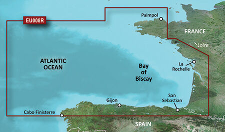
VEU008R-Bay of Biscay
Details: Informationen Produktcode VEU008R Name Bay of Biscay Typ Garmin BlueChart g3 Vision Abdeckung From Binic, France to Cabo Finisterre, Spain. Kompatibilität siehe Reiter Kompatible Plotter Kartenupdate Hier klicken
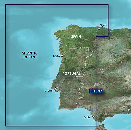
VEU009R-Portugal & Northwest Spain
Details: Informationen Produktcode VEU009R Name Portugal & Northwest Spain Typ Garmin BlueChart g3 Vision Abdeckung From Gijón to Cadiz and Sevilla, including the entire coast for Portugal. Kompatibilität siehe Reiter Kompatible Plotter Kartenupdate Hier klicken
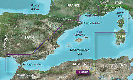
VEU010R-Spain,Mediterranean Coast
Details: Informationen Produktcode VEU010R Name Mediterranean Sea, Genova-Ayamonte Typ Garmin BlueChart g3 Vision Abdeckung Detailed coverage of the entire Spanish and French Mediterranean coast from the Straight of Gibraltar to La Spezia, IT. Includes coverage of Corse, the northern part of Sardegna, and the Islas Baleares. Also covers the northern coasts of Morocco and Algeria from Larache, MA, to Bejaia, DZ. Kompatibilität siehe Reiter Kompatible Plotter Kartenupdate Hier klicken
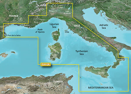
VEU012R-Mediterranean Sea, Central-West
Details: Informationen Produktcode VEU012R Name Mediterranean Sea, Central-West Typ Garmin BlueChart g3 Vision Abdeckung Detailed coverage of the Mediterranean coast from Islas Medas, ES to Crotone, IT, including the coasts of France, Monaco, and the west coast of Italy. Also includes detailed coverage of Lago Maggiore, Lago D' Iseo, and Lago di Garda in Northern Italy. Island coverage features Corse, Sardegna, Sicilia, and Malta. Kompatibilität siehe Reiter Kompatible Plotter Kartenupdate Hier klicken
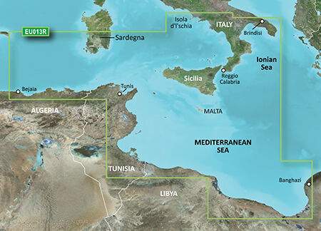
VEU013R-Italy Southwest & Tunisia
Details: Informationen Produktcode VEU013R Name Italy Southwest & Tunisia Typ Garmin BlueChart g3 Vision Abdeckung Italian coast: from Isola d'Ischia, south to Reggio Calabria, northeast to Brindisi, including Sicilia and southern part of Sardegna. African coast: from Golfe de Bejaia, Algeria to Banghazi, Libya. Kompatibilität siehe Reiter Kompatible Plotter Kartenupdate Hier klicken
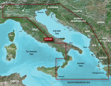
VEU014R-Italy, Adriatic Sea
Details: Informationen Produktcode VEU014R Name Italy, Adriatic Sea Typ Garmin BlueChart g3 Vision Abdeckung Detailed coverage of several Italian lakes, the Po River and the Adriatic coast of Italy, Slovenia, Croatia, Albania, the western coast of Greece and southern Italy. Coverage includes eastern Sicily, the Straits of Messina, the Dalmatian Coast, the Gulf of Taranto, Lago Maggiore, Lago d'Iseo, Lago di Como and Lago d'Garda. Kompatibilität siehe Reiter Kompatible Plotter Kartenupdate Hier klicken
Garmin Seekarten und elektronische Karten
Eine aktuelle elektronische Seekarte ist ein wichtiger Bestandteil moderner Navigation an Bord. Garmin Kartenplotter können mit detaillierten digitalen Seekarten für unterschiedliche Fahrtgebiete ausgestattet werden. Bei LEPPER marine finden Sie passende Garmin Seekarten für Kartenplotter in verschiedenen Kartografien und Ausstattungsvarianten.
Unser Sortiment umfasst Garmin BlueChart g3, BlueChart g3 Vision, Garmin Navionics+ und Garmin Navionics Vision+. Je nach Kartenserie stehen unterschiedliche Darstellungen, Zusatzinformationen und Funktionen zur Verfügung.
Garmin Karten für Kartenplotter
Die richtige Seekarte hängt nicht nur vom gewünschten Fahrtgebiet ab. Entscheidend ist auch, welcher Garmin Kartenplotter verwendet wird und welche Kartengeneration unterstützt wird.
Deshalb sollte vor dem Kauf immer die Kompatibilität zwischen Karte und Kartenplotter geprüft werden.
Bei LEPPER marine finden Sie elektronische Seekarten für zahlreiche Garmin Kartenplotter und Fahrtgebiete.
Garmin BlueChart g3
Garmin BlueChart g3 ist eine elektronische Seekartenlösung für kompatible Garmin Kartenplotter.
Die Karten kombinieren Garmin- und Navionics-Kartendaten und bieten detaillierte Informationen für die Navigation. Je nach Gebiet stehen unter anderem detaillierte Tiefenlinien, Tiefenbereichsschattierungen und Flachwasserschattierungen zur Verfügung.
Auch die Planung von Routen wird unterstützt. Garmin beschreibt die Auto Guidance-Funktion dabei als Planungsfunktion, die unter anderem gewünschte Tiefen und Durchfahrtshöhen berücksichtigen kann.
BlueChart g3 Karten sind für unterschiedliche europäische und internationale Fahrtgebiete erhältlich. Dazu gehören beispielsweise Nord- und Ostsee, Großbritannien, Mittelmeer und weitere Regionen.
Garmin BlueChart g3 Vision
BlueChart g3 Vision erweitert die klassische BlueChart-Kartografie um zusätzliche Funktionen und Informationen.
Je nach Kartengebiet können beispielsweise zusätzliche Detailinformationen, Satellitenbilder oder perspektivische Ansichten zur Verfügung stehen.
BlueChart g3 Vision eignet sich daher besonders für Skipper, die neben der klassischen elektronischen Seekarte zusätzliche Informationen zur Orientierung und Planung nutzen möchten.
Garmin Navionics+
Mit Garmin Navionics+ bietet Garmin eine moderne elektronische Seekartenlösung auf Basis der Navionics-Kartografie.
Je nach Abdeckung stehen detaillierte Informationen für Küstenbereiche, Häfen, Ankerplätze und Binnengewässer zur Verfügung.
Für die Auswahl ist insbesondere das gewünschte Fahrtgebiet entscheidend. Garmin Navionics+ Karten sind in verschiedenen regionalen Abdeckungen erhältlich.
Garmin Navionics Vision+
Garmin Navionics Vision+ kombiniert detaillierte Seekartendaten mit erweiterten Funktionen und zusätzlichen Informationen.
Damit richtet sich die Kartenserie insbesondere an Skipper, die ihren Garmin Kartenplotter für eine besonders umfangreiche Navigation und Törnplanung einsetzen möchten.
Welche Funktionen und Abdeckungen zur Verfügung stehen, hängt von der jeweiligen Karte und Region ab.
Welche Garmin Seekarte ist die richtige?
Die Auswahl der richtigen Garmin Karte lässt sich im Wesentlichen auf drei Fragen reduzieren:
1. Welches Fahrtgebiet benötigen Sie?
Wählen Sie die Karte entsprechend Ihrer Küstenregion beziehungsweise Ihres geplanten Törns.
2. Welchen Garmin Kartenplotter verwenden Sie?
Nicht jede Kartengeneration ist mit jedem Garmin Plotter kompatibel. Prüfen Sie deshalb vor dem Kauf die Kompatibilitätsangaben.
3. Welche Kartendarstellung und Zusatzfunktionen benötigen Sie?
BlueChart g3, BlueChart g3 Vision, Garmin Navionics+ und Garmin Navionics Vision+ unterscheiden sich hinsichtlich Kartografie und verfügbarer Zusatzfunktionen.
Garmin Seekarten für Nordsee und Ostsee
Für deutsche Skipper sind insbesondere Garmin Seekarten für Nordsee und Ostsee interessant.
Je nach Kartengebiet stehen detaillierte Abdeckungen für die deutsche Küste sowie angrenzende Gewässer zur Verfügung. Auch Regionen wie Dänemark, Schweden, Polen, die Niederlande und weitere europäische Küstenbereiche sind mit entsprechenden Karten abgedeckt.
Bei der Auswahl sollte immer auf die exakte regionale Abdeckung der jeweiligen Karte geachtet werden.
Garmin Seekarten für das Mittelmeer
Auch für das Mittelmeer stehen zahlreiche Garmin Seekarten zur Verfügung.
Je nach Region sind beispielsweise Karten für die spanische, französische, italienische oder griechische Küste erhältlich. Auch die Balearen, das Mittelmeer rund um die Türkei und weitere Reviere werden durch unterschiedliche Kartenregionen abgedeckt.
Damit können Sie die Karte passend zu Ihrem geplanten Törn auswählen.
Garmin Seekarten für Europa
Das Sortiment an Garmin Seekarten umfasst zahlreiche europäische Fahrtgebiete.
Dazu gehören unter anderem:
-
Nordsee
-
Ostsee
-
Großbritannien
-
Irland
-
Frankreich
-
Spanien
-
Portugal
-
Mittelmeer
-
Italien
-
Griechenland
-
Türkei
-
weitere europäische Küstenregionen
Welche Gebiete eine konkrete Karte abdeckt, entnehmen Sie bitte der jeweiligen Produktbeschreibung.
Garmin Seekarte auf microSD / SD-Karte
Viele Garmin Seekarten werden auf microSD- beziehungsweise SD-Karte angeboten.
Welche Speicherkarte beziehungsweise welches Kartenformat für Ihren Kartenplotter benötigt wird, hängt vom jeweiligen Garmin Modell ab.
Vor der Bestellung sollte deshalb immer geprüft werden, welches Speichermedium der eigene Kartenplotter unterstützt.
Garmin Karten aktualisieren
Bei elektronischen Seekarten spielt die Aktualität der Kartendaten eine wichtige Rolle.
Je nach Kartenserie und Produkt stehen unterschiedliche Möglichkeiten für Kartenupdates zur Verfügung. Bei der Auswahl sollte deshalb auch berücksichtigt werden, ob eine Karte bereits aktuelle Daten enthält und welche Update-Möglichkeiten vorgesehen sind.
Bei LEPPER marine finden Sie sowohl klassische Garmin BlueChart g3 Karten als auch die neueren Garmin Navionics+ und Garmin Navionics Vision+ Kartenserien.
Garmin Seekarten bei LEPPER marine
Als Spezialist für Marine-Elektronik bieten wir bei LEPPER marine eine große Auswahl an Garmin Seekarten für Kartenplotter.
Neben den elektronischen Seekarten finden Sie bei uns auch passende Garmin Kartenplotter, GPS-Geräte, Echolote und weiteres Zubehör.
Bei der Auswahl der richtigen Karte kommt es insbesondere auf Kartentyp, Fahrtgebiet und Kompatibilität mit dem vorhandenen Garmin Kartenplotter an.
Wenn Sie unsicher sind, welche Garmin Seekarte für Ihren Plotter und Ihr Fahrtgebiet geeignet ist, unterstützen wir Sie gerne bei der Auswahl.