
Garmin BlueChart g3 Vision – Größe Regular
Regionale Seekarten mit umfangreicher Kartenabdeckung
Hier finden Sie Garmin BlueChart g3 Vision Seekarten der Größe Regular für zahlreiche Fahrtgebiete weltweit.
Die Karten bieten detaillierte elektronische Seekartografie für kompatible Garmin Kartenplotter und ergänzen die BlueChart-g3-Kartografie um zusätzliche Vision-Funktionen wie hochauflösende Reliefdarstellung, Satellitenbilder und 3D-Ansichten – abhängig von Kartenregion und kompatiblem Gerät.
Die BlueChart g3 Vision Karten der Größe Regular decken unter anderem Regionen in Europa, Skandinavien, dem Mittelmeer, Afrika, dem Nahen Osten, dem Indischen Ozean, Grönland und der Karibik ab.
Wählen Sie die passende Karte anhand des gewünschten Fahrtgebiets und der angegebenen geografischen Abdeckung.
Wichtig: Prüfen Sie vor dem Kauf die Kompatibilität Ihres Garmin Kartenplotters mit BlueChart g3 Vision.

BlueChart g3 Vision Seekartenmodul REGULAR VEU059R (010-C1002-00)
Details: Informationen Produktcode VEU059R Name Greenland East Typ Garmin BlueChart g3 Vision Abdeckung Detailed coverage of the Eastern coast of Greenland from Germania Land around the southern tip of Greenland to Godthab (Nuuk) on the SW coast: Also details Jameson Land, Ammassalik, Julianehåb (Qaqortoq), and Nanortalik. Kompatibilität siehe Reiter Kompatible Plotter Kartenupdate Hier klicken
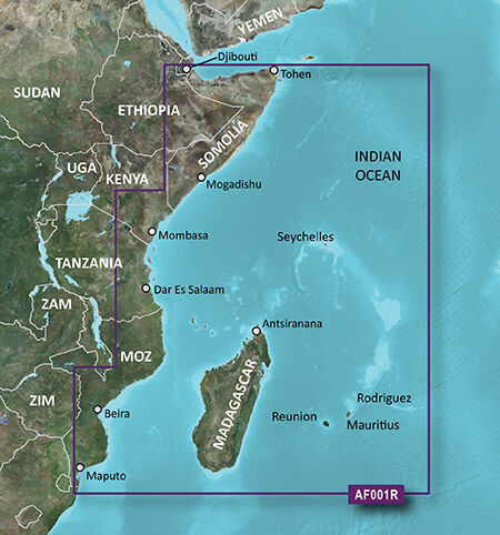
microSD™/SD™ card: VAF001R-Eastern Africa
Details: Informationen Produktcode VAF001R Name Eastern Africa Typ Garmin BlueChart g3 Vision Abdeckung General coverage of the east coast of Africa from the Gulf of Tadjoura to the Bay of Maputo, including Mogadishu, Som., Mombasa, Ken., and Dar es Salaam, Tan. Also includes general coverage of the entire coast of Madagascar. Includes detailed coverage of Djibouti, Dji., Maputo, Moz., Mauritius, Reunion, and the Seychelles. Kompatibilität siehe Reiter Kompatible Plotter Kartenupdate Hier klicken
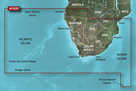
microSD™/SD™ card: VAF002R-South Africa
Details: Informationen Produktcode VAF002R Name South Africa Typ Garmin BlueChart g3 Vision Abdeckung Detailed coverage of the coast of southern Africa from Namibe, Ang. to Angoche, Moz., including the South African cities of Cape Town and Port Elizabeth. Includes detailed coverage of Durban S. Af. and Maputo, Moz. Also includes detailed coverage of the Tristan da Cunha Group, the island of St. Helena, and the Prince Edward Islands. Kompatibilität siehe Reiter Kompatible Plotter Kartenupdate Hier klicken
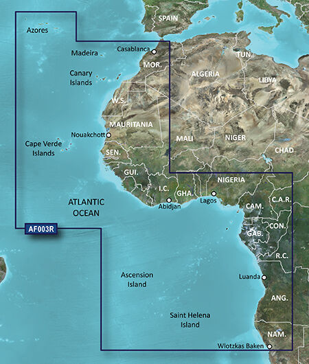
microSD™/SD™ card: VAF003R-Western Africa
Details: Informationen Produktcode VAF003R Name Western Africa Typ Garmin BlueChart g3 Vision Abdeckung General coverage of the west coast of Africa from El Aaraich, Mor. to Cape Cross, Nam., including Abidjan, C.I., Douala, Cam. and Luanda, Ang. Included in this overall general coverage are a number of detailed charts covering areas such as Casablanca, Mor., Dakar, Sen., and Lagos, Nig. Also includes general coverage of St. Helena Is., Ascension Is., and the Azores. Also includes detailed coverage of the Madeira Islands, Canary Islands, and Cape Verde Islands. Kompatibilität siehe Reiter Kompatible Plotter Kartenupdate Hier klicken
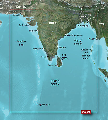
microSD™/SD™ card: VAW003R-Indian Subcontinent
Details: Informationen Produktcode VAW003R Name Indian Subcontinent Typ Garmin BlueChart g3 Vision Abdeckung General coverage of the Indian subcontinent from Pasni, Pak., to Sandoway, Myan. Included in this overall general coverage are a number of detailed charts covering areas such as the Indian cities of Mangalore, Quilon, and Calcutta. Also includes general coverage of Sri Lanka, the Andaman and Nicobar Islands, the Chagos Archipelago, and the Maldives, except for the detailed coverage of the Male Atoll Kompatibilität siehe Reiter Kompatible Plotter Kartenupdate Hier klicken
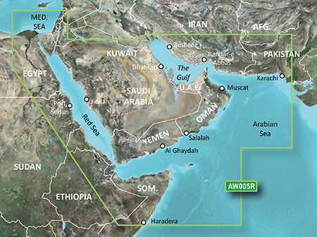
microSD™/SD™ card: VAW005R-The Gulf and Red Sea
Details: Informationen Produktcode VAW005R Name The Gulf & Red Sea Typ Garmin BlueChart g3 Vision Abdeckung Coverage of the Arabian Penninsula beginning at the Mediterranean Sea from Beirut to Alexandria. Coverage includes the Suez Canal, Gulf of Aqaba, and the Red Sea and Gulf of Aden in their entirety. Includes the Strait of Hormuz, Gulf of Oman, and coast of Somalia in the south. Coverage the of Kuwait, Saudi Arabia, Qatar, United Arab Emirates, along the southern coast of the Gulf and Iran along the northern coast. Coverage of Yemen and Oman coasts along the Indian Ocean to the Gulf of Oman, including Pakistan along the north coast, with general coverage of the Arabian Sea from Qamar Bay to the Delta of the Indus River. Included in this overall general coverage are numerous detailed charts covering areas such as Alexandria, Egy., Beirut, Leb., Al-Fuhaihil, Ad- Dammam, Bahrain, Ad-Dauha, and Abu Dhabi.Jiddah, Sau., Djibouti, Dji., and Aden, Yem. Kompatibilität siehe Reiter Kompatible Plotter Kartenupdate Hier klicken

microSD™/SD™ card: VUS030R-Southeast Caribbean
Details: Informationen Produktcode VUS030R Name Southeast Caribbean Typ Garmin BlueChart g3 Vision Abdeckung Covers the Caribbean from Haiti to Trinidad & Tobago, including Puerto Rico and all of the Lesser Antilles. Also includes the Colombian and Venezuelan coasts from Barranquilla, Colombia to the mouth of the Orinoco River, including Lake Maracaibo and the Gulf of Paria. Kompatibilität siehe Reiter Kompatible Plotter Kartenupdate Hier klicken

microSD™/SD™ card: VUS031R-Southwest Caribbean
Details: Informationen Produktcode VUS031R Name Southwest Caribbean Typ Garmin BlueChart g3 Vision Abdeckung Detailed coverage of the northern coast of Central America from Cancun, Mexico to Barranquilla, Colombia, including the Panama Canal in its entirety. General coverage of the northern half of the Gulf of Panama. Also includes detailed coverage of the coasts of Cuba, Jamaica, and the Caymans in their entirety Kompatibilität siehe Reiter Kompatible Plotter Kartenupdate Hier klicken

microSD™/SD™ card: VUS032R-Southern Gulf of Mexico
Details: Informationen Produktcode VUS032R Name Southern Gulf of Mexico Typ Garmin BlueChart g3 Vision Abdeckung Covers the Gulf of Mexico from Matagorda Bay to Belize City, including Corpus Christi, TX, Veracruz, Mex., the Bay of Campeche, Cancun, Mex., and Cozumel, Mex. Kompatibilität siehe Reiter Kompatible Plotter Kartenupdate Hier klicken
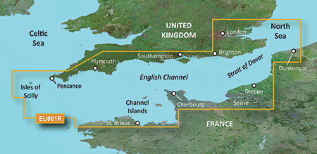
VEU001R-English Channel
Details: Informationen Produktcode VEU001R Name English Channel Typ Garmin BlueChart g3 Vision Abdeckung British coast: covers from Felixstowe to the Isles of Scilly, including Dover, The Solent, and the Isle of Wight. Also covers the River Thames from Twickenham to the North Sea. French coast: covers from Dunkerque to L'Aber Wrac'h, including Rouen and the Channel Islands Kompatibilität siehe Reiter Kompatible Plotter Kartenupdate Hier klicken
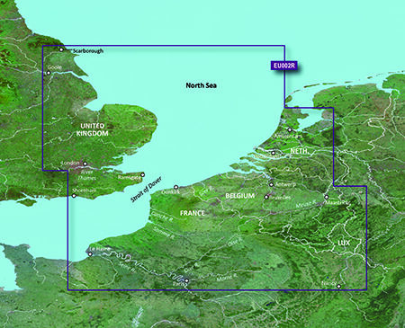
VEU002R-S/E England-Belux Inland Waters
Details: Informationen Produktcode VEU002R Name Dover-Amsterdam & England S/E Typ Garmin BlueChart g3 Vision Abdeckung British coast: from Scarborough Harbour to Newhaven, including River Thames to London. Continental coast: from Amsterdam to Fecamp. Kompatibilität siehe Reiter Kompatible Plotter Kartenupdate Hier klicken
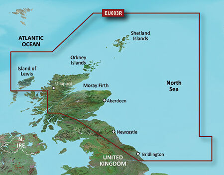
VEU003R-Great Britain, Northeast Coast
Details: Informationen Produktcode VEU0036R Name Great Britain, Northeast Coast Typ Garmin BlueChart g3 Vision Abdeckung Covers from the Isle of Lewis, Scotland to Bridlington Harbour, England, including Gairloch, the Shetland Islands, Edinburgh, and North Sea offshore charts. Also includes the Caledonian Canal, Loch Linnhe, and Loch Ness. Kompatibilität siehe Reiter Kompatible Plotter Kartenupdate Hier klicken
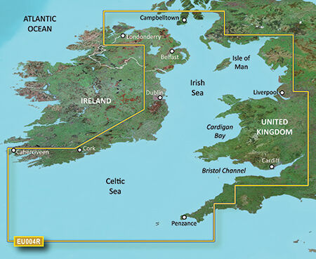
VEU004R-Irish Sea
Details: Informationen Produktcode VEU004R Name Irish Sea Typ Garmin BlueChart g3 Vision Abdeckung British coast: covers from Port Ellen on the Isle of Islay to Falmouth, including the Isle of Man and the Isles of Scilly. Irish coast: covers from Sheep Haven to Caherciveen, Republic of Ireland, including Londonderry, The Storks, Belfast, and Dublin. Kompatibilität siehe Reiter Kompatible Plotter Kartenupdate Hier klicken
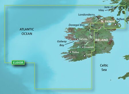
VEU005R-Ireland, West Coast
Details: Informationen Produktcode VEU005R Name Ireland, West Coast Typ Garmin BlueChart g3 Vision Abdeckung Detailed coverage of the north and western coasts of Ireland from Cork to Belfast including the Shannon Inland and Shannon-Erne Waterways, Galway Bay and Lough Neagh. Also included is the southwestern Scottish coast from Colonsay to Campbeltown. Kompatibilität siehe Reiter Kompatible Plotter Kartenupdate Hier klicken
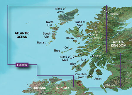
VEU006R-Scotland, West Coast
Details: Informationen Produktcode VEU046R Name Scotland, West Coast Typ Garmin BlueChart g3 Vision Abdeckung Scottish coast: Covers from the Isle of Lewis and Loch Bervie to Campbeltown Harbour and Girvan, including Glasgow, Ayr, and the islands of Skye, Arran, and many others. Kompatibilität siehe Reiter Kompatible Plotter Kartenupdate Hier klicken
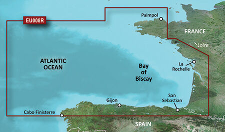
VEU008R-Bay of Biscay
Details: Informationen Produktcode VEU008R Name Bay of Biscay Typ Garmin BlueChart g3 Vision Abdeckung From Binic, France to Cabo Finisterre, Spain. Kompatibilität siehe Reiter Kompatible Plotter Kartenupdate Hier klicken
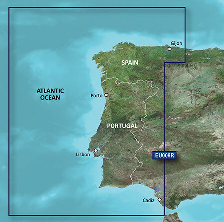
VEU009R-Portugal & Northwest Spain
Details: Informationen Produktcode VEU009R Name Portugal & Northwest Spain Typ Garmin BlueChart g3 Vision Abdeckung From Gijón to Cadiz and Sevilla, including the entire coast for Portugal. Kompatibilität siehe Reiter Kompatible Plotter Kartenupdate Hier klicken
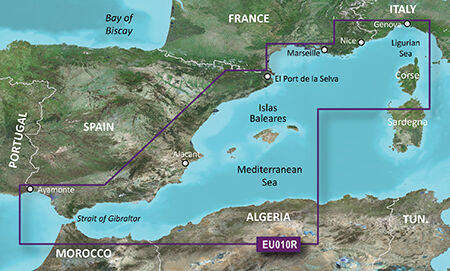
VEU010R-Spain,Mediterranean Coast
Details: Informationen Produktcode VEU010R Name Mediterranean Sea, Genova-Ayamonte Typ Garmin BlueChart g3 Vision Abdeckung Detailed coverage of the entire Spanish and French Mediterranean coast from the Straight of Gibraltar to La Spezia, IT. Includes coverage of Corse, the northern part of Sardegna, and the Islas Baleares. Also covers the northern coasts of Morocco and Algeria from Larache, MA, to Bejaia, DZ. Kompatibilität siehe Reiter Kompatible Plotter Kartenupdate Hier klicken
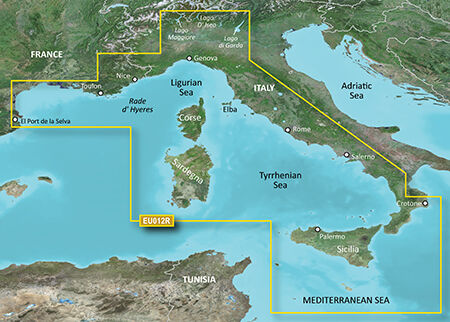
VEU012R-Mediterranean Sea, Central-West
Details: Informationen Produktcode VEU012R Name Mediterranean Sea, Central-West Typ Garmin BlueChart g3 Vision Abdeckung Detailed coverage of the Mediterranean coast from Islas Medas, ES to Crotone, IT, including the coasts of France, Monaco, and the west coast of Italy. Also includes detailed coverage of Lago Maggiore, Lago D' Iseo, and Lago di Garda in Northern Italy. Island coverage features Corse, Sardegna, Sicilia, and Malta. Kompatibilität siehe Reiter Kompatible Plotter Kartenupdate Hier klicken
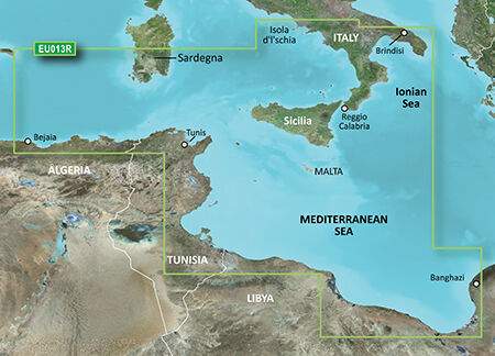
VEU013R-Italy Southwest & Tunisia
Details: Informationen Produktcode VEU013R Name Italy Southwest & Tunisia Typ Garmin BlueChart g3 Vision Abdeckung Italian coast: from Isola d'Ischia, south to Reggio Calabria, northeast to Brindisi, including Sicilia and southern part of Sardegna. African coast: from Golfe de Bejaia, Algeria to Banghazi, Libya. Kompatibilität siehe Reiter Kompatible Plotter Kartenupdate Hier klicken
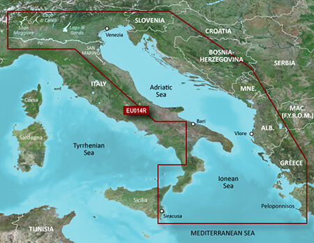
VEU014R-Italy, Adriatic Sea
Details: Informationen Produktcode VEU014R Name Italy, Adriatic Sea Typ Garmin BlueChart g3 Vision Abdeckung Detailed coverage of several Italian lakes, the Po River and the Adriatic coast of Italy, Slovenia, Croatia, Albania, the western coast of Greece and southern Italy. Coverage includes eastern Sicily, the Straits of Messina, the Dalmatian Coast, the Gulf of Taranto, Lago Maggiore, Lago d'Iseo, Lago di Como and Lago d'Garda. Kompatibilität siehe Reiter Kompatible Plotter Kartenupdate Hier klicken
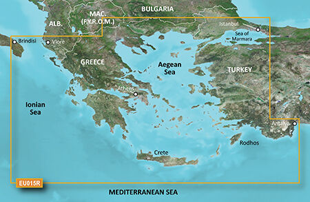
VEU015R-Aegean Sea & Sea of Marmara
Details: Informationen Produktcode VEU015R Name Aegean Sea & Sea of Marmara Typ Garmin BlueChart g3 Vision Abdeckung Including all of the Greek coast and Aegean Sea; Turkey from Istanbul and Sea of Marmara to Antalya; and Brindisi, Italy. Kompatibilität siehe Reiter Kompatible Plotter Kartenupdate Hier klicken
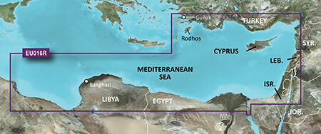
VEU016R-Mediterranean Southeast
Details: Informationen Produktcode VEU016R Name Mediterranean Southeast Typ Garmin BlueChart g3 Vision Abdeckung From Güllük, Turkey east to include Cyprus, Syria, Lebanon and Israel, then west to Misratah, Libya. Kompatibilität siehe Reiter Kompatible Plotter Kartenupdate Hier klicken
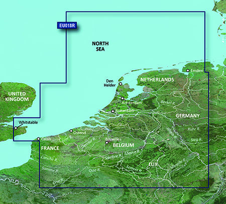
VEU018R-Benelux Offshore & Inland
Details: Informationen Produktcode VEU018R Name The Netherlands Typ Garmin BlueChart g3 Vision Abdeckung Continental coverage: from Spiekeroog, Germany to Calais, France, including The Netherlands and Belgium coast entirely. Great Britain coverage: from Whitstable to Folkestone. Kompatibilität siehe Reiter Kompatible Plotter Kartenupdate Hier klicken
Garmin BlueChart g3 Vision Seekarten Größe Regular
Die Garmin BlueChart g3 Vision Karten der Größe Regular bieten detaillierte elektronische Seekartografie für zahlreiche regionale Fahrtgebiete weltweit.
BlueChart g3 Vision basiert auf der BlueChart-g3-Kartografie und erweitert diese um zusätzliche Funktionen für Navigation und Törnplanung. Je nach Kartenregion und kompatiblem Garmin Kartenplotter stehen unter anderem hochauflösende Reliefdarstellung, Satellitenbilder, 3D-Ansichten sowie zusätzliche Hafen- und Marinainformationen zur Verfügung.
Bei LEPPER marine finden Sie BlueChart g3 Vision Regular Karten für unterschiedliche Regionen – von europäischen Küsten über das Mittelmeer bis hin zu internationalen Fahrtgebieten.
Was bedeutet Regular bei BlueChart g3 Vision?
Die Bezeichnung Regular (R) beschreibt die Abdeckungsgröße der jeweiligen Garmin Seekarte.
Sie ist Bestandteil der Garmin-Produktnummer, beispielsweise bei Karten mit der Kennung VEU001R oder VAF001R.
Wichtig: Regular bezeichnet nicht ein bestimmtes Fahrtgebiet. Die geografische Abdeckung ist bei jeder Karte individuell und kann sich erheblich unterscheiden.
Deshalb sollten Sie immer die beim jeweiligen Produkt angegebene Kartenabdeckung prüfen.
BlueChart g3 Vision Regular für Europa
Ein großer Teil des Sortiments umfasst europäische Fahrtgebiete.
Dazu gehören unter anderem:
-
Ärmelkanal
-
Großbritannien
-
Irland
-
Nordsee
-
Benelux
-
Frankreich
-
Portugal
-
Spanien
-
Mittelmeer
-
Italien
-
Adria
-
Griechenland
-
Türkei
Die einzelnen Karten decken jeweils definierte Regionen ab. So umfasst beispielsweise die Karte VEU001R English Channel Bereiche der britischen und französischen Küste sowie die Themse und die Kanalinseln. Die Karte VEU018R Benelux Offshore & Inland deckt dagegen unter anderem die niederländische und belgische Küste sowie angrenzende Bereiche ab.
BlueChart g3 Vision Regular für das Mittelmeer
Für das Mittelmeer stehen mehrere regionale BlueChart-g3-Vision-Karten der Größe Regular zur Verfügung.
Je nach Karte werden unterschiedliche Bereiche abgedeckt, beispielsweise:
-
spanische und französische Mittelmeerküste
-
Balearen
-
Korsika und Sardinien
-
Italien
-
Adria
-
Griechenland
-
Ägäis
-
Türkei
-
Zypern
-
östliches Mittelmeer
-
Teile der nordafrikanischen Küste
Die Produktabdeckungen überschneiden sich teilweise. Deshalb lohnt sich ein genauer Vergleich der jeweiligen Kartenregion vor dem Kauf.
Internationale BlueChart g3 Vision Regular Karten
Die Regular-Kategorie ist nicht auf Europa beschränkt.
Bei LEPPER marine finden Sie auch BlueChart g3 Vision Karten für internationale Fahrtgebiete, darunter beispielsweise:
Grönland:
Die Karte VEU059R bietet detaillierte Abdeckung der Ostküste Grönlands sowie weiterer Bereiche rund um die Südspitze bis zur Westküste.
Afrika:
Für die afrikanischen Küsten stehen unter anderem Karten für Ostafrika, Südafrika und Westafrika zur Verfügung. Je nach Karte werden zusätzlich Inselgruppen und ausgewählte Häfen detailliert abgedeckt.
Indischer Subkontinent:
Eine weitere BlueChart-g3-Vision-Regular-Karte deckt den indischen Subkontinent sowie unter anderem Sri Lanka, die Malediven und weitere Inselgruppen ab.
Golf und Rotes Meer:
Die entsprechende Kartenabdeckung umfasst unter anderem das Rote Meer, den Golf von Aden, den Golf von Oman und den Persischen Golf.
Karibik:
Mehrere Regular-Karten decken unterschiedliche Bereiche der Karibik und angrenzender Küsten ab, darunter die Kleinen Antillen, Puerto Rico, Kuba, Jamaika und Teile Mittelamerikas.
BlueChart g3 Vision Regular oder andere Abdeckungsgröße?
Welche Kartengröße die richtige ist, hängt von Ihrem Fahrtgebiet und der gewünschten regionalen Abdeckung ab.
Bei Garmin BlueChart g3 Vision finden Sie unterschiedliche Abdeckungsgrößen:
-
Small (S)
-
Regular (R)
-
Large (L)
Die Bezeichnung beschreibt die jeweilige geografische Kartenabdeckung. Eine größere Abdeckung ist nicht automatisch die bessere Wahl – entscheidend ist, welche Regionen Sie tatsächlich befahren möchten.
Wenn Ihr Fahrtgebiet auf eine bestimmte Region begrenzt ist, kann eine kleinere Abdeckung ausreichend sein. Für umfangreichere Törns kann eine größere Kartenabdeckung sinnvoll sein.
BlueChart g3 Vision mit Premium-Funktionen
BlueChart g3 Vision erweitert die klassische BlueChart-g3-Kartografie um zusätzliche Darstellungen und Funktionen.
Je nach Region können unter anderem folgende Funktionen zur Verfügung stehen:
-
hochauflösende Reliefdarstellung
-
Satellitenbilder
-
3D-Ansichten
-
zusätzliche Hafen- und Marinaansichten
-
detaillierte nautische Kartografie
-
Tiefeninformationen und Tiefenbereichsschattierung
-
Auto Guidance auf kompatiblen Garmin Kartenplottern
Die tatsächlich verfügbaren Funktionen können je nach Kartenregion und Kartenplotter variieren.
Welche BlueChart g3 Vision Regular Karte benötige ich?
Bei der Auswahl sollten Sie auf drei Punkte achten:
1. Fahrtgebiet
Welche Küsten, Inseln oder Binnengewässer möchten Sie befahren?
2. Kartenabdeckung
Vergleichen Sie die geografische Abdeckung der einzelnen Karten. Gerade im Mittelmeer und bei internationalen Fahrtgebieten können sich verschiedene Kartenregionen überschneiden.
3. Kompatibilität
Prüfen Sie, ob Ihr konkreter Garmin Kartenplotter BlueChart g3 Vision unterstützt.
Die Kompatibilität sollte vor dem Kauf immer anhand des konkreten Plottermodells geprüft werden.
Garmin BlueChart g3 Vision bei LEPPER marine
Bei LEPPER marine finden Sie eine umfangreiche Auswahl an Garmin BlueChart g3 Vision Regular Seekarten für europäische und internationale Fahrtgebiete.
Ob Nordsee, Mittelmeer, Karibik, Afrika, Grönland oder weitere Regionen – wählen Sie Ihre Seekarte anhand der konkreten Kartenabdeckung und Ihres geplanten Fahrtgebiets.
Wenn Sie unsicher sind, welche BlueChart-g3-Vision-Karte für Ihren Garmin Kartenplotter und Ihr Fahrtgebiet geeignet ist, unterstützen wir Sie gerne bei der Auswahl.